
Discover Uri | A Visitor's Introduction to Uri
Recommended places to visit, places to stay and things to do in and around Uri
Uri is a mountainous canton in central Switzerland, extending from the southern end of Lake Lucerne through the Reuss Valley to the high passes surrounding Andermatt. Known for its association with William Tell, the historic Gotthard route and dramatic Alpine scenery, this compact region is a perfect destination for walkers, railway enthusiasts, cyclists and travellers seeking quieter Swiss landscapes. With its lakeside villages, deep gorges and strategically important mountain passes, Uri offers a distinctive journey through the geographical and cultural heart of Switzerland.
Recommended Uri hotels and other accommodation
Pre-book Uri Attractions, Tours & Experiences
Why is Uri Worth a Visit?
Uri is worth visiting because it brings together several elements central to Switzerland’s national story. The canton is closely associated with William Tell and the foundation legends of the Swiss Confederation, while its position on the Gotthard route made it a vital connection between northern Europe and Italy.
The landscape changes dramatically from north to south. Around Flüelen and Sisikon, steep mountains descend towards the fjord-like waters of Lake Lucerne. Farther south, the Reuss Valley narrows into dramatic gorges before reaching Andermatt and the high Alpine passes.
Uri is particularly rewarding for travellers who prefer scenery and outdoor activity to large-city sightseeing. Its principal settlements are small, public transport is generally excellent, and walking routes begin close to railway stations, boat landings and cable cars.
The canton also works well as part of a longer Swiss journey. Visitors can combine Lake Lucerne with the historic Gotthard railway, continue south towards Ticino or travel west from Andermatt towards the Furka Pass and the Valais.
Uri Highlights: Things to See and Do in Uri
Explore Altdorf
Altdorf is Uri’s cantonal capital and the centre of its William Tell traditions.
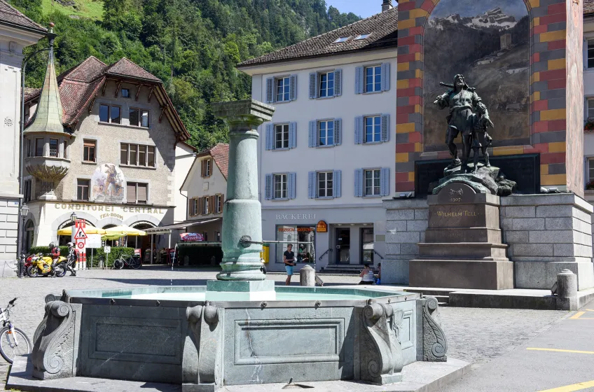
The main square is dominated by a monument showing Tell with his crossbow beside his son. According to legend, Tell was forced to shoot an apple from the boy’s head after refusing to bow before the Habsburg governor’s hat.
Historic buildings, cafés and public offices surround the square. Although Altdorf is small, it provides the best introduction to Uri’s political and cultural history.
The town is slightly inland from Lake Lucerne. Buses connect it with Flüelen railway station and surrounding communities.
Visit the Tell Monument
The William Tell Monument is Altdorf’s most recognisable landmark.
The bronze sculpture presents Tell as a determined father and national hero rather than simply a legendary marksman. Inscriptions and nearby displays help explain his role in Swiss identity.
The surrounding square is easy to explore and often forms the starting point for guided walks. A tower beside the monument may offer elevated views when accessible.
Even visitors who regard Tell primarily as a myth will find the site useful for understanding how the story has shaped Uri and Switzerland.
Discover the Tell Museum in Bürglen
Bürglen, just outside Altdorf, is traditionally regarded as William Tell’s home village.
The Tell Museum explores the development of his legend through paintings, books, documents, sculptures and popular culture. Rather than attempting to prove that Tell existed, the displays show how his story has been interpreted over time.
Bürglen also contains a church and small historic centre surrounded by steep green slopes. The village is easily reached by local bus from Altdorf.
Cruise Lake Lucerne to Flüelen
Flüelen stands at the southern end of Lake Lucerne and forms Uri’s principal lakeside transport hub.
Passenger boats connect it with Brunnen, Bauen, Isleten, Lucerne and other destinations around the lake. The journey between Lucerne and Flüelen is one of Switzerland’s finest lake voyages, passing cliffs, historic sites and mountain settlements.
Flüelen’s waterfront has promenades, cafés and views towards the surrounding peaks. It is also a convenient interchange between boats, buses and trains.
Seasonal timetables vary, so check the final sailing before planning a one-way walk or excursion.
Visit Tell’s Chapel
Tell’s Chapel stands on the eastern shore of Lake Lucerne near Sisikon.
According to legend, William Tell escaped from a boat during a storm by jumping onto the rocky shore at this location. The chapel contains painted scenes illustrating episodes from his story.
The site is especially memorable when approached by boat or on foot along the lakeside trail. Its position beneath steep mountains gives it a dramatic sense of isolation.
Access can depend on seasonal boat services and walking conditions. Visitors arriving on foot should wear suitable shoes, as some paths are steep or uneven.
Walk the Swiss Path
The Swiss Path, or Weg der Schweiz, follows the southern shores of Lake Lucerne around the historic heartland of the Swiss Confederation.
Different sections represent the cantons in the order in which they joined Switzerland. The route passes forests, meadows, villages and lakeside viewpoints.
Uri’s sections connect places including Flüelen, Tell’s Chapel and Sisikon. Some stages are gentle, while others involve steps, slopes and significant height changes.
Boats and trains make it easy to walk one section and return by public transport. Carry water, as refreshment options are limited on quieter stretches.
Explore the Rütli Meadow
The Rütli Meadow lies across the water from Uri on the shore of Lake Lucerne and is traditionally associated with the oath that founded the Swiss Confederation.
Although geographically in the neighbouring canton of Uri? The meadow is actually in the canton of Uri and is most naturally reached by boat from Brunnen or other lake ports.
The open meadow, simple memorials and surrounding mountain scenery create a deliberately understated national monument.
There is no road access directly to the site. Arriving by boat and walking uphill from the landing stage is part of the experience.
See the Schöllenen Gorge
The Schöllenen Gorge lies between Göschenen and Andermatt, where the River Reuss cuts through steep rock walls.
The gorge was one of the greatest obstacles on the historic Gotthard route. Its famous Devil’s Bridge is associated with legends about supernatural assistance in constructing a crossing through the dangerous landscape.
Modern bridges, railway lines, tunnels and military structures now occupy the gorge alongside the older route. The contrast between natural drama and transport engineering is remarkable.
Walking paths provide access to viewpoints and memorials, but conditions can be slippery or icy outside summer. Check local access before setting out.
Visit Andermatt
Andermatt is Uri’s best-known mountain resort, positioned in the Ursern Valley near the meeting point of several major Alpine passes.
The old village retains traditional houses, narrow lanes and a compact centre, while newer hotels and resort developments have expanded the range of accommodation and restaurants.
In winter, Andermatt is a major ski destination linked with Sedrun and Disentis. The Gemsstock area is particularly known for steep terrain and reliable high-altitude snow.
Summer brings hiking, cycling, golf and scenic train journeys. Andermatt also makes a useful base for exploring the Gotthard, Furka and Oberalp passes.
Travel the Historic Gotthard Railway
The historic Gotthard mountain railway is one of Switzerland’s great engineering achievements.
Between Erstfeld, Göschenen and Airolo, trains climb through loops, spiral tunnels and mountain scenery before passing through the original Gotthard Tunnel. The repeated views of Wassen’s church help reveal how the line gains height.
Many faster trains use the lower Gotthard Base Tunnel and spend much of the journey underground. Choose a service specifically using the panoramic mountain route when scenery is the priority.
The railway can be combined with a Lake Lucerne boat journey through the Gotthard Panorama Express or planned independently using regional trains.
Explore the Gotthard Pass
The Gotthard Pass has been a crucial route across the Alps for centuries.
At the summit, visitors can see small lakes, historic buildings, old road surfaces and exhibitions explaining transport through the mountains. The landscape is stark, rocky and often windswept.
The Tremola road on the southern side is famous for its cobbled hairpin bends. It is popular with cyclists and motorists but requires caution in poor weather.
The pass is seasonal and generally closes during winter. Snow can remain late into spring, so always check road and bus conditions.
Ride Over the Furka Pass
The Furka Pass connects Andermatt with the upper Rhône Valley and provides some of Switzerland’s most dramatic road scenery.
The route passes high peaks, waterfalls and views towards the Rhône Glacier. The historic Furka steam railway operates on part of the old mountain line during the warmer months.
The pass is highly seasonal and may remain closed well into early summer. Weather conditions can change rapidly, and road traffic includes coaches, motorcycles and cyclists.
Public buses cross the pass during the operating season, allowing visitors to enjoy the scenery without driving.
Travel Across the Oberalp Pass
The Oberalp Pass links Andermatt with Sedrun and the canton of Graubünden.
Trains climb across the pass throughout much of the year, with snow galleries and winter operations making it one of the region’s most dependable scenic routes.
Near the pass lies Lake Toma, traditionally regarded as the source of the Rhine. Reaching it requires a mountain walk rather than a quick roadside stop.
The route forms part of the Glacier Express journey between Zermatt and St Moritz, although ordinary regional trains provide greater flexibility.
Walk in the Maderanertal
The Maderanertal is a secluded side valley reached from the Reuss Valley near Amsteg.
Its landscape includes waterfalls, forests, mountain pastures and views towards glaciers and high peaks. The valley feels significantly quieter than Andermatt or Lake Lucerne.
A narrow road and local transport lead towards the upper valley, from where walking routes continue to mountain hotels and huts.
Facilities are limited, so carry food, water and weather protection. Some routes are suitable for casual walkers, while others enter demanding Alpine terrain.
Visit the Reuss Delta
The Reuss Delta lies where the river enters Lake Lucerne near Flüelen and Seedorf.
Restored wetlands, shallow water and islands provide habitats for birds, fish and other wildlife. Walking and cycling paths cross parts of the landscape.
The flat terrain makes the area suitable for families and visitors seeking an easy outdoor activity. It also offers broad views towards the lake and mountains.
Swimming is permitted only in designated places, and protected zones should be respected.
Practical Advice for Visitors
Getting There
Uri lies on the main railway route between central Switzerland and Ticino.
Trains connect towns such as Erstfeld, Altdorf and Flüelen with Lucerne, Zug, Zurich and Bellinzona. Andermatt is reached via the regional railway from Göschenen or from Disentis and Brig.
From Zurich, Altdorf can generally be reached in around one to one and a half hours, depending on the service. Lucerne is approximately an hour away by train from much of northern Uri.
Zurich Airport is the most convenient major international gateway. Milan airports may also be useful when combining Uri with Ticino or northern Italy.
Choosing Where to Stay
Altdorf is the best base for Tell heritage, local history and central access to northern Uri.
Flüelen suits visitors interested in Lake Lucerne boats, cycling and rail connections. Its waterfront setting is more scenic than central Altdorf.
Andermatt is the strongest base for skiing, mountain passes, high-level walking and scenic railway journeys. It has the broadest resort infrastructure but is generally more expensive.
Smaller communities such as Sisikon, Seedorf and Bürglen provide quieter accommodation, though restaurant and evening transport choices may be limited.
Getting Around
Swiss trains, buses and boats integrate well, making Uri practical without a car.
Regional buses connect Altdorf with Bürglen, mountain villages and side valleys. Trains serve the principal Reuss Valley settlements, while boats operate across Lake Lucerne.
Andermatt is connected to Göschenen by a steep mountain railway. Trains also continue west towards Brig and east across the Oberalp Pass.
Check evening and Sunday timetables carefully, especially for small villages and mountain valleys.
Driving
The A2 motorway follows the Reuss Valley and enters the Gotthard Road Tunnel near Göschenen.
Heavy congestion can develop at the tunnel, particularly during weekends, public holidays and summer travel periods. Delays of several hours are possible on the busiest days.
Swiss motorways require a vignette. Mountain passes do not generally need the motorway vignette when reached entirely by ordinary roads, but your wider route may still use motorway sections.
Pass roads are seasonal, steep and exposed. Carry warm clothing, check weather conditions and avoid underestimating journey times.
Parking
Altdorf, Flüelen and Andermatt have public car parks, but spaces can fill during events and peak holiday periods.
Andermatt parking is particularly busy during ski weekends and summer pass traffic. Some hotels charge separately for garage spaces.
Trailhead parking in side valleys may be limited or subject to fees. Use local buses where practical.
Do not park on narrow access roads, farm entrances or avalanche-control areas.
Dining
Uri’s cuisine reflects Alpine farming traditions. Cheese, potatoes, dried meat and substantial soups appear frequently.
A regional speciality is Urner Pastete, a pastry traditionally filled with dried fruit, nuts or savoury ingredients depending on the recipe.
Cheese dishes, rösti, sausages and dried meats are widely available. Mountain restaurants often serve simple meals based on local dairy products.
Andermatt has the widest dining range, including traditional inns and more upscale restaurants. Smaller villages may have only one or two options and limited kitchen hours.
Shopping
Typical regional purchases include Alpine cheese, dried meat, honey, spirits and products linked to William Tell.
Andermatt has sports shops, bakeries and souvenir retailers, while Altdorf provides more everyday shopping.
Small dairies and farm shops may sell cheese directly, although opening hours can be irregular.
Switzerland uses the Swiss franc. Cards are widely accepted, but cash remains useful at mountain huts, small farms and unattended kiosks.
When to Visit
June to September is the main period for hiking, cycling, lake boats and mountain-pass travel.
July and August offer the broadest transport schedules but also bring traffic around the Gotthard route and higher accommodation prices.
September is often excellent for walking, with cooler temperatures and clearer air. Some mountain facilities begin closing later in the month.
December to March is the main ski season in Andermatt. Conditions in the lower Reuss Valley may be wet rather than snowy.
April, May, October and November are transition periods. Mountain roads, cable cars and seasonal hotels may be closed.
Local Events
Swiss National Day on 1 August has particular significance in Uri because of the canton’s association with the early Confederation. Celebrations may include speeches, music, bonfires and lake events.
Traditional wrestling, folk music and Alpine festivals take place in villages throughout the year.
Andermatt hosts concerts, sporting events and seasonal guest programmes during both summer and winter.
Altdorf and neighbouring communities hold markets, cultural performances and events connected with William Tell.
Dates change annually, so check the regional programme before arranging travel around a specific event.
Exploring Beyond Uri
Lucerne is the easiest city excursion, offering a preserved old town, museums, lakeside promenades and mountain connections.
Brunnen and Schwyz provide further insight into the traditional heartland of the Swiss Confederation.
Ticino lies south of the Gotthard, with Bellinzona, Locarno and Lugano offering Italianate architecture, warmer weather and palm-lined lakes.
The Valais can be reached westwards from Andermatt across the Furka route or by train, leading towards Brig and Zermatt.
Graubünden lies east of the Oberalp Pass and provides access to Disentis, the Rhine Valley and the wider Glacier Express route.
Shortlist
- Your Shortlist is empty